
quite fascinated by the theme boundary
because as the designers that’s
something that with you with on a daily
basis so you see boundaries could be
physical as you see in this picture is a
suburban gated community outside of
Beijing you see multiple layers of it
divided vertical walls in the city so
that’s a physical boundary
it could be intangible conceived in the
perceived in someone’s mind only even
though it has the dangerous potential to
become real
so unfortunately those two quick
examples showed us how boundaries could
make the world more segregated in a less
diverse even though in general to us
boundaries help us delineate and
differentiate things in the context so
the world could be more diverse and now
let’s do something fun it’s not a rocket
science
so don’t overthink – trust your eyes –
raise your hands if you think the second
oranda line or the middle the middle
line is longer than the rest with your
hands if you think the middle one is
longer so I see some hands okay but the
reality as the red lines are the exact
same length so all three of them is are
the same and let’s look at the MC
ensures classic mind-boggling peace
relativity in this drawing you see each
stairway is perfect perfectly logical
but once you see the whole picture were
baffled how different universes can
coexist without even a clear spatial
boundary you see they’re they’re logical
but the whole picture doesn’t make sense
and it’s getting more fun now wake up
raise your hands if you you can
recognize the celebrity okay I’m going
to turn this photo upside down 180
degrees so sometimes our perceptions can
can be deceiving now I showed you the
physical boundaries I showed you
perceive the boundaries they’re not
always aligned this happens to our
cities as well
this is this could be anywhere in China
if I review the second part of the city
it shows how our cities have extended
this so one of the typical urban fabric
that we see today in most of the Chinese
cities and unfortunately this is how we
accept the preconceived notion that we
need to divide the land we need to
impose boundaries first so we can have a
rule to follow this is not a different
from the upside-down picture that I
showed you and if we assume that we’re
doing the right thing
so in logic is it’s almost the same so
to me as a designer the city the cities
will look very raw unfriendly and
flavorless so it’s as if as a planner as
a designer I serve you a dish of
separated ingredients there is no flavor
what if you have a flavor you need that
mix you need that interaction you can
eat that magical chemical reaction
so in a result this is what our cities
look like today this is a corner of
Shanghai you see the urban fabric as
both homogenous and fragmented
and the high density of vertical
development as a nut layer of boundary
on top of natural natural boundary so
the otherwise beautiful water edge is it
orbited by these towers and that this is
supposed to be the biggest residential
block in Changsha so align the entire
why are we doing this to our cities it
has a history in China since 1950s the
Soviet Union inspired or influenced
urban planning has dominated Chinese
cities for decades and with the
monumental why drills in boulevards
lined with compound after compounds
government departments and military
agencies normally acquire a big swath of
land by providing their employees and
their residents with the wide array of
different amenities simple as a sign or
symbol of a privilege there’s another
reason behind this especially in the
recent decades we’ll see more and more
gated residential communities and this
graph shows that most of the local
governments get there about 20% of their
revenue from land Alesi so this is their
fifth favor to model by efficiently
outsource outsourcing at land if you
private developers so you can share some
of the cost and or even structure
development and so that’s what our
cities look like today so urban traffic
congestions has become a conundrum for
almost every city but we keep on
building more lanes the wider world but
the traffic gets worse and one of my
colleague has a really good metaphor he
was saying that keep on adding more
wider rows to deal with the traffic is
this it’s like someone keep loosening
his belt to deal with overweight and
even when there’s no traffic this is
early shot in one of the neighborhoods
in Beijing you see there there’s no
urban life there’s no street life and
there’s no interaction no connectivity
along the street and what are we trying
to protect us from with three layers of
walls into such a simple Street and the
neighbors are not even interacting to
each other and that you will notice that
there’s a narrow stretch of green
sandwiched between the wall and the
walk that is not accessible not a
recreational not even visible to most of
the residents behind the walls and this
is extremely inefficient in effective in
and so where is this going
now we see the trend we see the history
we see with we see the impact we see the
problems let’s look at the evolution of
land land use planning in Chinese cities
quickly so from the graph you’ll see
clearly that the trend it is from
completely separate second occasion of
different land uses industrial is here
open space Park is here and residential
is here towards a better integration and
a synergy among them all and today and
you all know the the top downturn term
from the central Chinese government it’s
called a Chang Chun Lanka or change in
your own code that means different land
uses different different urban
productions need to talk to each other
each you interact with each other also
like a cookie you’re creating that
chemistry that the reaction so you can
add more flavor to the cities and just
last spring in 2016 the central
government announced to ban all the
gated future gated communities and
gradually open over the existing ones
now a tool to alleviate traffic pressure
but we all know that traffic congestion
is just one of the symptoms it’s not the
core problem and we notice some of the
developments that they’re not a designed
to face outside there were in water
facing they’re not designed to interact
with with the river with outside of the
urban fabric and let’s look at what else
is needed for the cities there isn’t a
clear answer or for all and we can
easily done over the rating systems or
sustainable design and development let’s
look at some of the simple prerequisite
to see where we are or where
the Chinese cities are and it’s there
are two examples among many to measure
the conductivity and the openness of a
neighborhood of a community one is
density of intersection in an in the
proximity of a neighborhood
and the second one is proximity to to
open space for ninety percent of the
residents so eligible you need a fifty
four intersections per square kilometre
they’re just a benchmark but let’s look
at the same example that I showed you
earlier
the city has only 14 intersections this
is a new so-called eco city it’s only
about a quarter of the baseline per lead
and the question mark is you see that
the rivers the open space has no
connection to the large gated community
at all and that there’s a a lane road
separating the river from from from the
neighborhood
so the mental distance is much longer
even though you’re you can see the river
but it’s not accessible so now I’m going
to share it with you a few examples of
our own practice how designers deploy
concept of a boundary to promote a
stronger public realm and advocated for
ecology so this is green eco Park in New
York City in Manhattan that way we did
in the nineteen seventy this was one of
the earlier prototypes of new public
space even though as part of the private
prevalent owned
residential neighborhood it was not
completely gated at all instead it
opened to the public and 40 years later
today is still one of many people’s
favorite open space in New York and we
can ask John of this to this picture of
Chicago River Walk taken seven years ago
as you’ll see the hostile urban
waterfront that is supporting no
activities there attracting no
pedestrians or wildlife many many levels
but this is what it looks like
a-and for designers like us we see the
edges we see the boundaries as
opportunities where you bring different
experiences different if energies to
converge to collide to have their
chemical reaction to to add flavor to
the cities and the still to linear
narrow edge now it’s being celebrated as
a urban destination one of the most
popular ones in Chicago this this is
what now what it looks like today with
the various you know activities after
different seasons in different time of
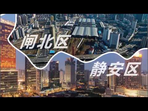
the day and the next one is a pseudo
Creek and many of you may have been to
Shanghai Suzhou quick pens demos to
historical water water course meandering
through the oldest part of Shanghai the
core of downtown and for a long time for
generations the surgically has been
credited as one of the drivers behind
modern industrialization in Shanghai but
sometimes in the recent decades people
only remember sort of quick as urban
blight as a with the nickname black and
distinct in Chinese hey Cho I remember
in the 1990s I lived in Shanghai and
super-quick is not any where ever you
want to get close to or you want your
address to be associated with so this is
taken up with it and it’s not only a
divided by the self as a as a mental
mental boundary to between the socially
under represented the district on the
north bank and the wealthy cosmopolitan
district in the south so in 2015 the
combination of those two security
districts create the opportunity for
designers like us to look at their own
this linear feature or boundary could be
really valuable something really
celebrated in the city and to unleash
the potential of this otherwise this
would divide and they’re not much
different from most of the other urban
rivers in China you see is pretty much
blocked by industrial uses
infrastructure
in the narrow space in between and a two
meter tall flood wall and it provides no
visual or pedestrian connectivity and
let’s look at the residential
neighborhood is similar to those Anil
cities there their design if you ignore
the water even though water is right at
the edge and the fence is be able to
ride along edge even by removing the
edge the neighborhood has no intention
to react with the water so apparently
there’s other need that for designer to
intervene to not only remove the
physical boundary you need to really
make the neighborhood’s open and by
remove that perceived boundary and while
we were doing design the new tower to
start to started encroaching toward the
river so it was desperately need a
holistic framework to really advocated
for a public realm and open space and
just to avoid the avoid making the same
mistake of having that solid wall along
the pub public open space and that this
was the vision that we we created so you
see there are two interacting linear
corridors but I’m going to rewind and
explain the logic behind it so everyone
else was focusing on this trying to fit
the program in this linear waterfront
because when people talk about a
waterfront that’s what you see that’s
the boundary does the scope but you’re
given
but for us instead we look at the
block-by-block
social data as well as circulation study
and we strategically pull the water edge
out into the neighborhood so one one way
this you can overcome the the social
stigma that soda Creek has created a
long time ago then at the same time it’s
not a random this is connecting all the
major urban nose infrastructure
including the central Shanghai station
and public parks so it creates a episode
of different activities and the space
between these two the red line which is
urban frontage and the Green Line along
the river which is the recreational
corridor becomes the public realm that
as the connecting tissue between
the new frontage or new address of
pseudo Creek and the open space corridor
and instead of no supporting private
holiday development along River so this
is trying to maximize open space along
the along River and so the internship
buildings are preserved to not only
celebrate the heritage of the entire
site and they become the social just art
destination that responding to the oriT
already quite a successful art district
on the other side of the creek and as
you see the ground the ground floor of
some industrial buildings warehouses
open up as a extension of the landscape
and and that provides a permeable a
public realm to connect from the train
station all the way to to the river and
so it not only connects all the actives
along the the creek they also extend
into the neighborhood and the existing
parks in the city so to create a
dialogue between the city and the new
Waterfront and then the gated
neighborhood again so we were opening it
up and not only but simply removing the
physical boundary we’re adding or into
intervening with the preservation as
well as a new program as for example by
adding inserting extending and
connecting new program so it becomes a
vibrant open and open community with a
mixed-use with a strong corridor and
view indication towards the the creek
and then instead of generic semi-private
open space in gated in neighborhoods in
the Neal Community Center and the
community parks become the social hub
that not only recreational and is it
just where people interact instead of
remember that bridging neighborhood that
you cannot even cross the street and it
they’ll ask four to five hundred meters
long so those are those are examples
that with designers often battle against
the boundaries this example then
sometimes we reinforce or re-establish
as well so
for example the nature doesn’t follow
any boundaries you know for example
water only follows the law of gravity
and not a not at all care how we divide
the urban fabric so most of the wetland
and in the river corridors in Chinese
cities are engineered these days with
the concrete embankments with very
little ecological functions or no
aesthetic value but instead we maximize
the riparian zones more than five times
to reverse that simplification process
by reintroducing habitats by
reintroducing well and so the nature can
work for us to purify water to to
provide ecosystem services and this is
how late through a layperson sighs to
see this landscape so instead of having
a artificial boundary on top of on top
of the natural boundary we we reinforce
it let’s use boundaries to make the world more diverse thank you